
Whitsundays Cruising Guide 2026
Seventy four islands sit inside a comfortable run of Airlie Beach, and almost all of the good ones are reachable in under an hour. That proximity is what makes the Whitsundays unusual. You are not committing to long passages between anchorages. You are choosing which sheltered bay you want to wake up in.
Cruising the Whitsundays: five routes from Airlie Beach
Seventy four islands sit inside a comfortable run of Airlie Beach, and almost all of the good ones are reachable in under an hour. That proximity is what makes the Whitsundays unusual. You are not committing to long passages between anchorages. You are choosing which sheltered bay you want to wake up in.
This guide sets out five self contained cruising routes, each starting and finishing at Coral Sea Marina. Take one for a long weekend. Thread three together for a week. Every route carries its approximate distance, the conditions it suits and the anchorages worth knowing about.
We run a fleet of Riviera motor yachts out of Coral Sea Marina year round, so this is written from the perspective of the people who move the boats.
When to go
The season runs from roughly May to October. Through those months the humidity drops, the water clears and the islands settle into the conditions they are known for. July through September is the peak, and it is also when humpbacks are calving in the passages between the islands.
November through April brings higher humidity, the chance of tropical lows, and stinger season inshore. It is still cruisable, and the islands are quieter, but it needs a closer eye on the forecast and full stinger suits for anyone getting in the water.
If you want the postcard version with the least compromise, aim for August and September.
How to use this guide. Each route below is a loop from Coral Sea Marina at Airlie Beach, sized to one or two days. None require an overnight passage. Suggested combinations for three, five and seven nights are further down the page. Distances are approximate and given for planning only.
Route One · approx 12 nautical miles · shortest run from the marina
Hook Island and the reef bays
The shortest run out of Airlie and still one of the best. Nara Inlet cuts deep into the south side of Hook Island and gives shelter in almost anything from the south, which is why it has been the standard first night stop for cruising boats for decades. A short climb from the dinghy landing reaches Ngaro cave art, some of the oldest recorded evidence of sea country in the region.
Carry on around the top of the island and the northern bays open up. Butterfly Bay, Manta Ray Bay, Luncheon Bay and Maureen's Cove hold the best snorkelling within easy reach of Airlie Beach, on fringing coral that starts a few metres off the rocks. There are public moorings throughout, so you rarely need to put an anchor down.
Anchorages
Nara Inlet · Butterfly Bay · Maureen's Cove · Stonehaven
On the water
The northern Hook bays are superb in settled conditions and get uncomfortable if the breeze goes into the north. Check the forecast before committing to an overnight up there and keep Nara Inlet in mind as the fallback. Swimming is not advised in Nara Inlet.
Route Two · approx 22 nautical miles · tide dependent
Whitehaven Beach and Hill Inlet
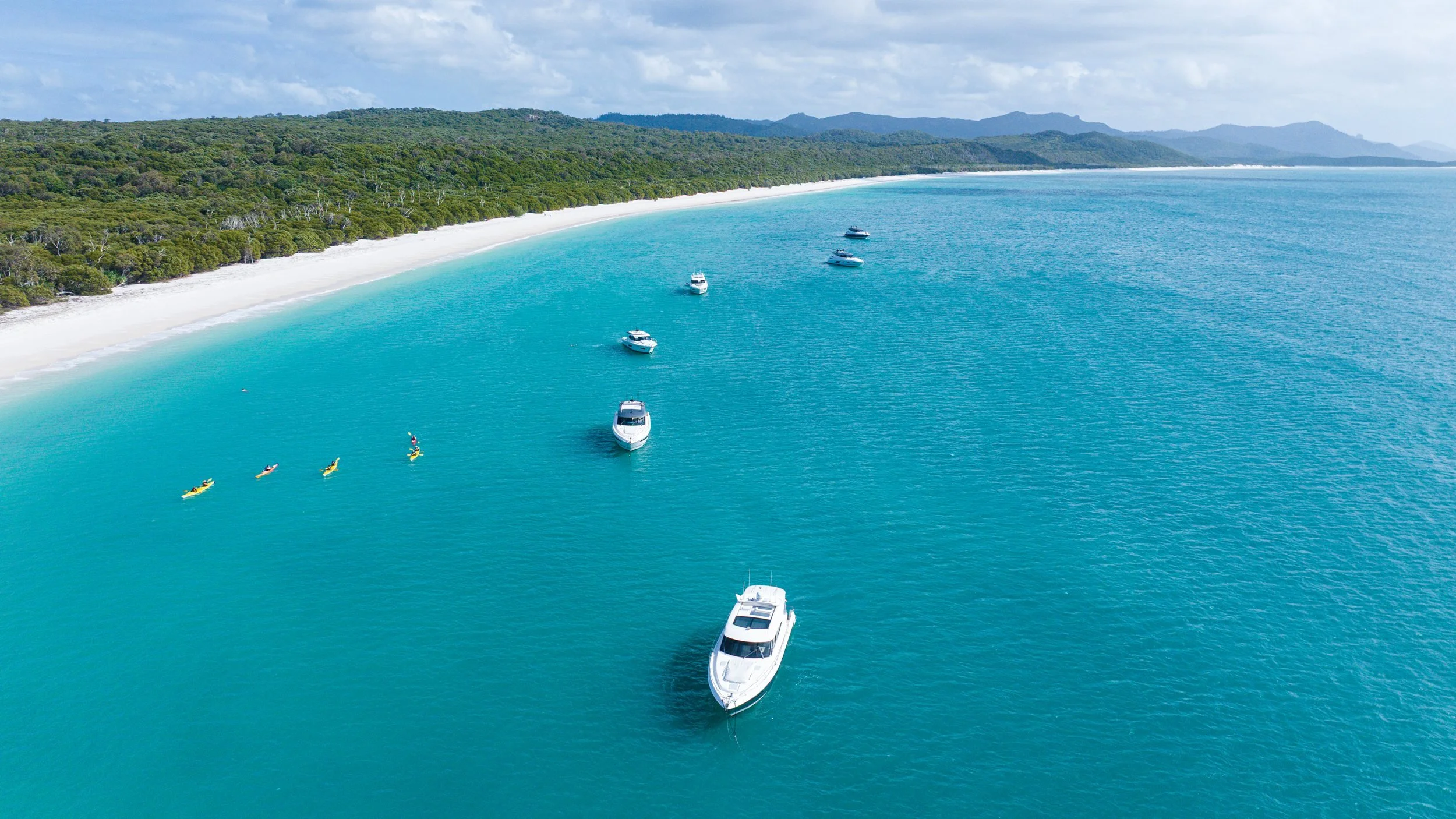
Seven kilometres of silica sand so fine it squeaks underfoot. Everyone comes to Whitehaven, and it is still worth it, because almost nobody stays. The day boats arrive mid morning and are gone by four.
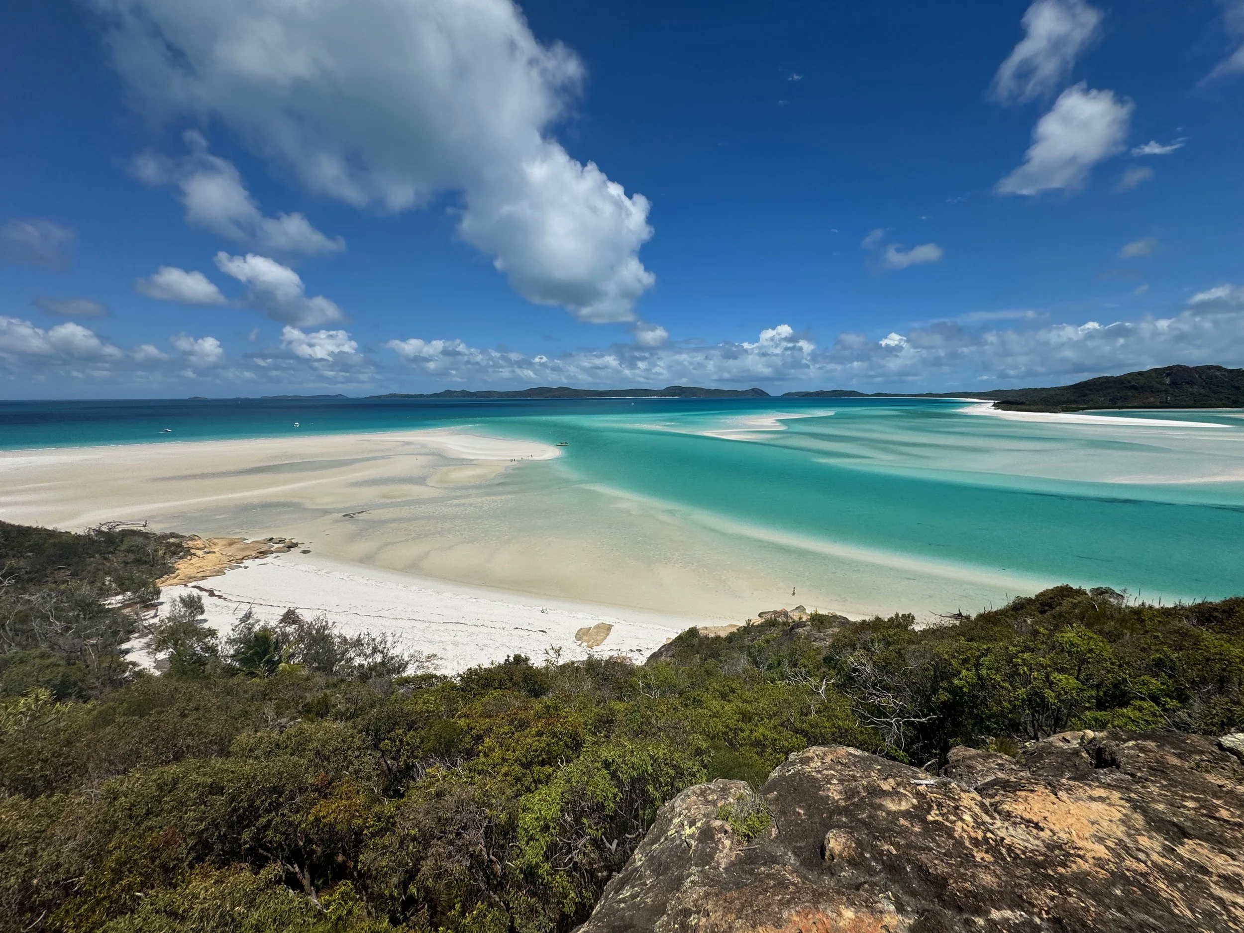
Anchor in Tongue Bay for the night, tender ashore, and walk twenty minutes up to the Hill Inlet lookout. Time it around a low to mid tide and the sandbanks separate into the ribbons of white and turquoise the region is known for. At high water it is simply a pretty bay. The tide makes the entire difference, and it is the most common planning mistake visitors make.
Cross Solway Passage for Chalkies Beach on Haslewood Island if you want the same sand without the crowd.
Anchorages
Tongue Bay · Chalkies Beach · Whitehaven southern end, daylight only
On the water
Whitehaven itself is an exposed anchorage, so treat it as a day stop and sleep in Tongue Bay. Hill Inlet is shallow and the sandbanks move between seasons. Take the tender in, never the mothership. Solway Passage runs hard on the tide, so plan the crossing rather than improvising it.
Route Three · approx 15 nautical miles · best on a falling tide
Hayman, Langford and the sand spits
The northern group is the quietest good cruising in the Whitsundays. Blue Pearl Bay on the western side of Hayman Island holds resident Maori wrasse and some of the healthiest fringing coral you will find inshore. Black Island, still called Bali Hai by anyone who has been coming here twenty years, is a short tender ride from a mooring.
The set piece is the Langford Island spit. On a falling tide a curved bar of white sand emerges out of open water, holds for a couple of hours, and disappears again. Take shade, take lunch, and have the tender ready before the tide turns.
Anchorages
Blue Pearl Bay · Langford Reef · Stonehaven · Black Island
On the water
The spit is entirely a function of the tide. Check the table the night before and build the day around it. Blue Pearl Bay is exposed to the west, so treat it as a day mooring in most conditions.
Route Four · approx 14 to 22 nautical miles · all weather shelter
Cid Harbour and the southern run
Cid Harbour is the great all weather anchorage of the Whitsundays. Deep, wide, protected from almost every direction, and the reason it has been a first night stop for cruising boats for fifty years. Land the tender at Sawmill Beach and walk up Whitsunday Peak, roughly three hours return and steep through the middle section, for a panorama across the entire island group.
From there, Gulnare Inlet for absolute stillness, or south to Hamilton Island for fuel, water and a night ashore.
Anchorages
Cid Harbour · Sawmill Beach · Gulnare Inlet · Hamilton Island Marina
Important
Cid Harbour is a signed no swimming area and has been since 2018. Do not swim, snorkel, paddle board or tow anyone there at any time. Local operators give the same advice for Nara Inlet, Gulnare Inlet and Hook Passage. Enjoy the anchorage, use the tender, and get in the water elsewhere.
Route Five · approx 30 nautical miles · settled conditions only
Bait Reef and the outer edge
This is the run most visitors never make, and the one people talk about afterwards. Bait Reef sits on the outer line where the continental shelf drops away. The Stepping Stones, a row of coral pinnacles along its edge, is genuine Great Barrier Reef rather than fringing island coral. Different water, different colour, different fish.
It is public moorings only. Bait Reef is an unmarked no anchoring area and anchoring there is an offence.
On the water
Only run this on a genuine weather window with a settled forecast either side of it. Bait Reef sits within a Marine National Park green zone, so no fishing or collecting, and all fishing apparatus must be stowed and out of the water while you are there.
Threading the routes together
Three nights
Route Two, then Route One. Whitehaven and Hill Inlet first while everyone is fresh, then work back through the Hook bays on the way home.
Five nights
Routes One, Three and Two. North first, then the crossing to Whitehaven, then home. Two snorkelling days, one beach day, and one day where nothing is scheduled.
Seven nights
Routes One, Three, Five, Two and Four. Build the outer reef run into the middle so you have days either side to move it if the forecast turns. Finish at Hamilton Island and come home along the southern shore.
Before you go
Public moorings
Blue double cone buoys, free, first come first served. The tag shows the vessel length, wind limit and time limit that applies. Time limits run between 7am and 5pm. Pick one up at or after 3pm and you can hold it until 9am the next morning. One vessel per mooring.
No anchoring areas
Bait Reef and Manta Ray Bay are unmarked no anchoring areas. Elsewhere, stay outside the reef protection markers and set down on sand or mud. Damaging coral is an offence under the Whitsundays Plan of Management.
In the water
No swimming at Cid Harbour. Nothing at dawn or dusk. No food scraps or fish waste over the side at any time, including at anchor. Avoid bait schools and diving birds. Always swim in pairs. Between November and May, full stinger suits inshore.
Whales
Humpbacks are in the passage from June through September, calving in the sheltered water between the islands. Slow down and give them room.
Fuel, water and provisions
Coral Sea Marina and Hamilton Island both have fuel and water. Provision in Airlie Beach before you leave. 100 Magic Miles remains the reference work for this coastline and is worth having aboard.
Cruising the Whitsundays on a share
Most people who cruise the Whitsundays either charter for a week or own a boat they use a fortnight a year. There is a third option.
Neptune Oceanic operates a fully managed fleet of Riviera motor yachts from Coral Sea Marina, alongside our Gold Coast and Sanctuary Cove bases. A one eighth share gives you forty two days a year plus flexi days, on a walk on walk off basis. The vessel is cleaned, fuelled, maintained, insured and berthed. You arrive, you go cruising, you hand back the keys.
Everything in this guide is within reach of a single share allocation.
Frequently asked questions
How many days do I need in the Whitsundays?
Three nights covers Whitehaven, Hill Inlet and the Hook Island bays. Five nights adds the northern islands and enough slack to sit out a bad forecast day. Seven nights lets you include the outer reef, which needs a weather window you cannot schedule in advance.
What is the best time of year to cruise the Whitsundays?
May to October. August and September are the peak, with the clearest water, the most settled conditions and humpbacks in the passages.
Do I need a boat licence?
In Queensland a recreational marine driver licence is required to operate a powered vessel above a set engine power threshold. Requirements change, so confirm the current position with Maritime Safety Queensland before you plan a trip.
Can I swim at Whitehaven Beach?
Yes, and it is one of the great swims anywhere. Cid Harbour is the anchorage where swimming is not permitted. Between November and May a full stinger suit is needed in inshore waters.
Do I need to book anchorages or moorings?
No. Public moorings throughout the islands are free and first come first served, with time limits shown on each mooring tag. Marina berths at Hamilton Island do need booking.
Can I take a boat to the outer Great Barrier Reef?
Bait Reef is about thirty nautical miles from Airlie Beach and reachable on a settled forecast. It is public moorings only and sits inside a green zone, so no fishing. It is not a trip to make on a marginal forecast.
What does a yacht share cost?
A one eighth share covers forty two days a year plus flexi days, with all management, berthing, maintenance and insurance included. Get in touch and we will send current pricing across the fleet.
Ready to plan a Whitsundays run?
Talk to us about what a share looks like and which vessel suits how you cruise.
Distances are approximate and given for planning only. Always navigate to current charts and the latest forecast.